Projects
An Interoperable Architecture for the Internet of COVID19 Things (IoCT) Using Open Geospatial Standards—Case Study: Workplace Reopening (2019)
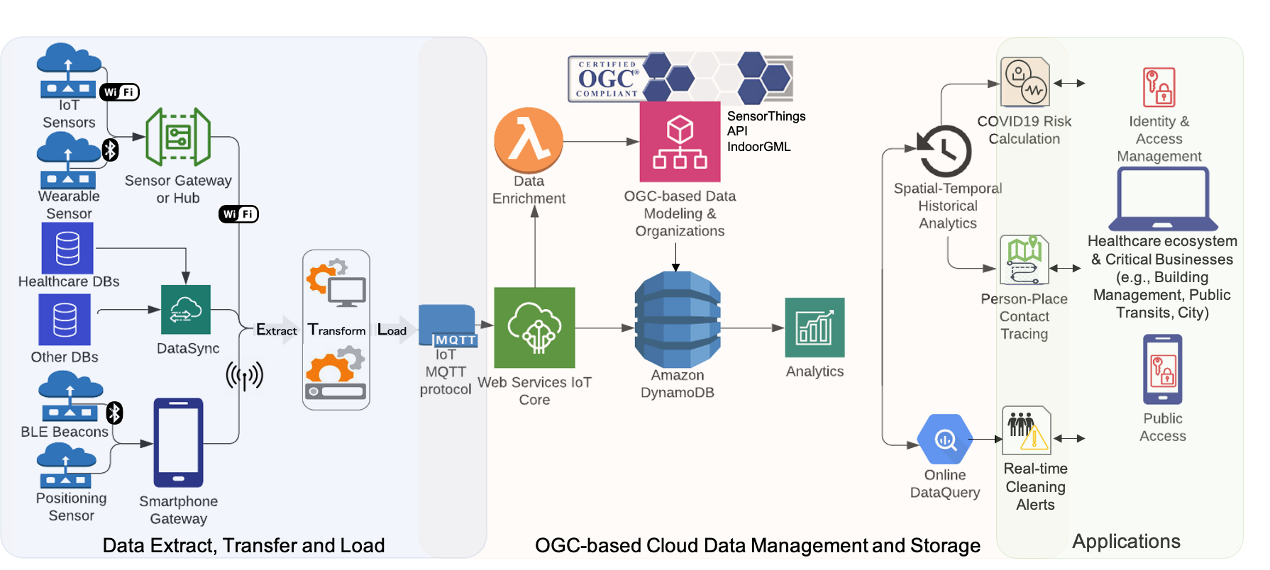
To safely protect workplaces and the workforce during and after the COVID-19 pandemic, a scalable integrated sensing solution is required in order to offer real-time situational awareness and early warnings for decision-makers. However, an information-based solution for industry reopening is ineffective when the necessary operational information is locked up in disparate real-time data silos. There is a lot of ongoing effort to combat the COVID-19 pandemic using different combinations of low-cost, location-based contact tracing, and sensing technologies. These ad hoc Internet of Things (IoT) solutions for COVID-19 were developed using different data models and protocols without an interoperable way to interconnect these heterogeneous systems and exchange data on people and place interactions. This research aims to design and develop an interoperable Internet of COVID-19 Things (IoCT) architecture that is able to exchange, aggregate, and reuse disparate IoT sensor data sources in order for informed decisions to be made after understanding the real-time risks in workplaces based on person-to-place interactions. The IoCT architecture is based on the Sensor Web paradigm that connects various Things, Sensors, and Datastreams with an indoor geospatial data model. This paper presents a study of what, to the best of our knowledge, is the first real-world integrated implementation of the Open Geospatial Consortium (OGC) Sensor Web Enablement (SWE) and IndoorGML standards to calculate the risk of COVID-19 online using a workplace reopening case study. The proposed IoCT offers a new open standard-based information model, architecture, methodologies, and software tools that enable the interoperability of disparate COVID-19 monitoring systems with finer spatial-temporal granularity. A workplace cleaning use case was developed in order to demonstrate the capabilities of this proposed IoCT architecture. The IoCT architecture included proximity-based contact tracing, people density sensors, a COVID-19 risky behavior monitoring system, and the contextual building geospatial data. View Full-Text: https://www.mdpi.com/1424-8220/21/1/50
**Publications:** We are pleased to announce that our recent GeoSensorWeblab’s publication on the Internet of COVID-19 Things has been selected and promoted as the cover story for the mdpi Sensors journal.
https://www.mdpi.com/1424-8220/21/1
OGC CDB: Advancing Interoperability for Dynamic Environmental Representations (2016 – Present)
The OGC CDB Project is a collaboration project with CAE Inc. to advance interoperability for dynamic environmental representations. Effective training and simulation requires producing a unified synthetic representation of the world. Each simulation generates a synthetic environment using various types of geospatial information and processes with redundancies and data inconsistencies. Applications of such dynamic Modeling and Simulation (M&S) include aviation, emergency response, defense and military, etc. To enhance realism and efficiency in dynamic M&S applications, one of the most pressing needs is a “plug-and-play” synthetic environment database that can be shared, reused, and repurposed. However the current situation is that M&S simulators require their own proprietary synthetic environment databases. The objective of this project is to develop an interoperable and high performance open geospatial standard specification for dynamic synthetic environmental representations.
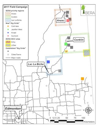
Boreal Ecosystem Recovery and Assessment (BERA) Project (2015 – 2020)
The BERA Project is a collaboration project to develop and build field research processes for collecting biodiversity data in Alberta's boreal forests. The GeoSensorWeb Lab is building remote sensing devices that can collect real-time data and publish to a public and standards-based platform, where users can view data on the web.
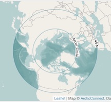
ArcticConnect (2014 – Present)
ArcticConnect is a CANARIE Network-Enabled Platform (NEP) project with the Arctic Institute of North America and Cybera, Inc. It is a set of tools and applications for improving geospatial visualization of data and research related to the arctic. The GeoSensorWeb Lab assisted in building multiple parts of the project.
ArcticWebMap
ArcticWebMap is a free tile server for OpenStreetMap data re-projected into multiple arctic-focused projections. This improves the display of shapes closer to the north pole. The tile server is actively maintained by the GeoSensorWeb Lab.
PolarMap.js is a part of ArcticWebMap, as a plugin for Leaflet.js to make integrating arctic maps easy.
ArcticScholar
ArcticScholar is a database of research and publications related to the arctic. The ArcticScholar database is maintained by the Arctic Institute of North America.
ArcticSensorWeb
ArcticSensorWeb lists various sensors from arctic sources. Data is from Environment Canada, INTERACT, and the Arctic Institute of North America.
ArcticBioMap
ArcticBioMap is a citizen reporting and data sharing mobile application for northern communities to collect biodiversity data and share it with researchers at the University of Calgary.
CANARIE RPI (2013 – 2014)
The CANARIE RPI was a project to expand previous NEP work with an open API for integration with future NEP projects as well as public access. The GeoSensorWeb Lab built an open HTTP database for accessing sensor metadata and sensor data, as well as a web front-end for visualizing the data.
EagleWatch Portal (2012)
A portal to view historical sightings data for migratory eagle species in the Canadian Rockies.
Rocky View County Well Watch (2011 – 2012)
A portal to view and submit ground water readings for well owners in the Rocky View County region of Alberta, Canada.
GeoCENS Project (2009 – 2013)
The Geospatial Cyberinfrastructure for Environmental Sensing (GeoCENS) project was a CANARIE RPI project created by the GeoSensorWeb Lab to catalog and view public OGC SOS data sources across the internet. It included a user discussion and data rating feature, to improve the rating of results. Data could be viewed online using the NASA WorldWind Java Applet. A translation engine layer was created to map SOS commands into an HTTP interface for easier consumption by web and javascript clients. A search engine crawler and database would search and catalog public SOS instances online, and provide that data to the portal with an HTTP interface.